I. Background
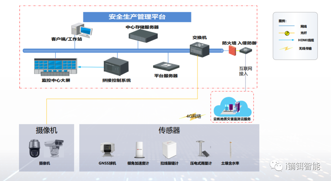
II. Solution
Slope Monitoring Based on Sensor Technology
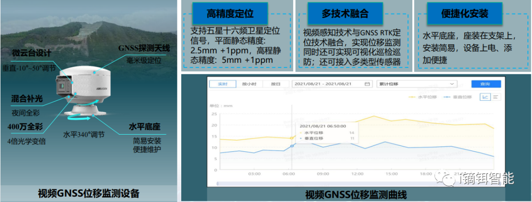
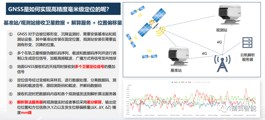
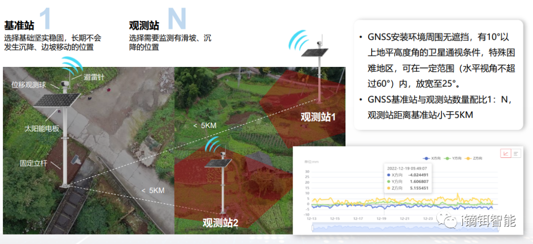
Video GNSS Displacement Monitoring
Surface displacement is a major trigger for geological hazards. Video GNSS equipment enables millimeter-level static accuracy for displacement monitoring, while also providing visual inspection of hazard points. Remote video inspection is supported through video linkage.
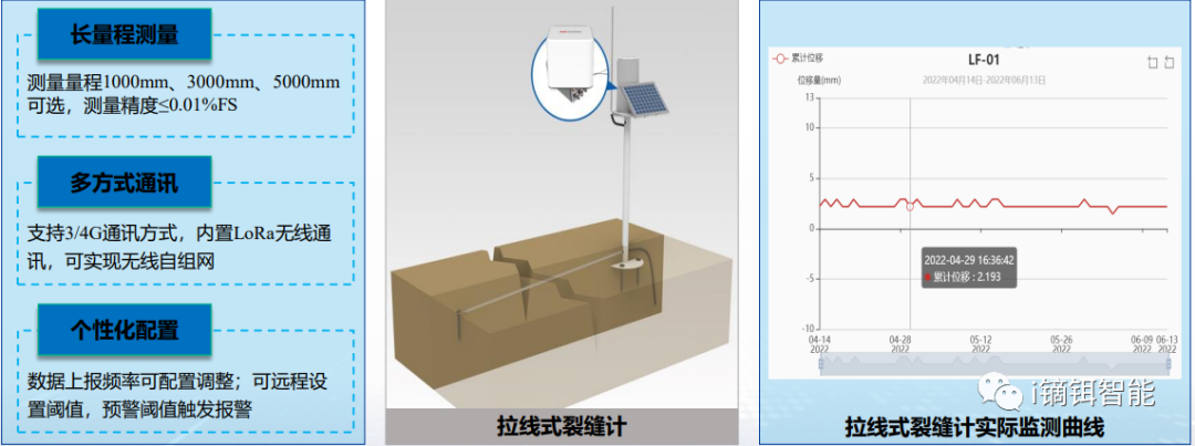
Crack Monitoring
Ground cracks are precursors to disasters, often appearing in settlement areas or around collapse zones. Wire-type crack gauges measure crack displacement for long-term monitoring.
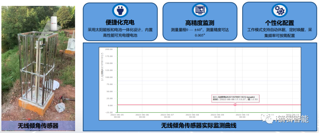
Tilt Monitoring
Tilt deformation is a key indicator of landslides and collapses. Wireless tilt sensors provide accurate tilt measurement for monitoring settlement and deformation.
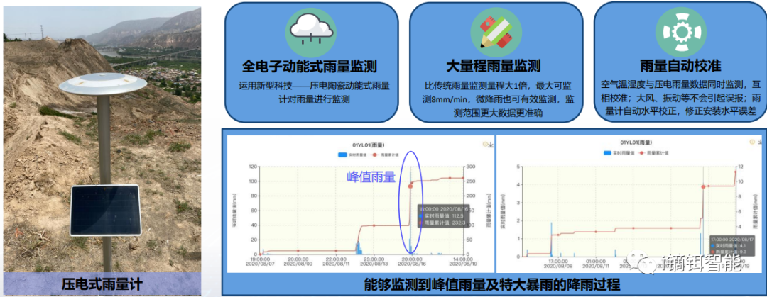
Rainfall Monitoring
Heavy rainfall is a major trigger for geological hazards. Piezoelectric rain gauges identify raindrop impact force to monitor rainfall levels from drizzle to heavy rain, with wider range, higher accuracy, and lower error.
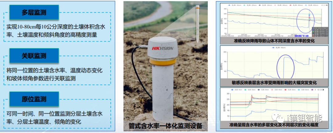
Soil Moisture
Rainfall-induced rapid changes in soil moisture are key triggers for debris flows and landslides. Tubular integrated moisture monitoring equipment simultaneously monitors both the trigger (moisture) and result (slope tilt) for multi-parameter correlation, improving data reliability.
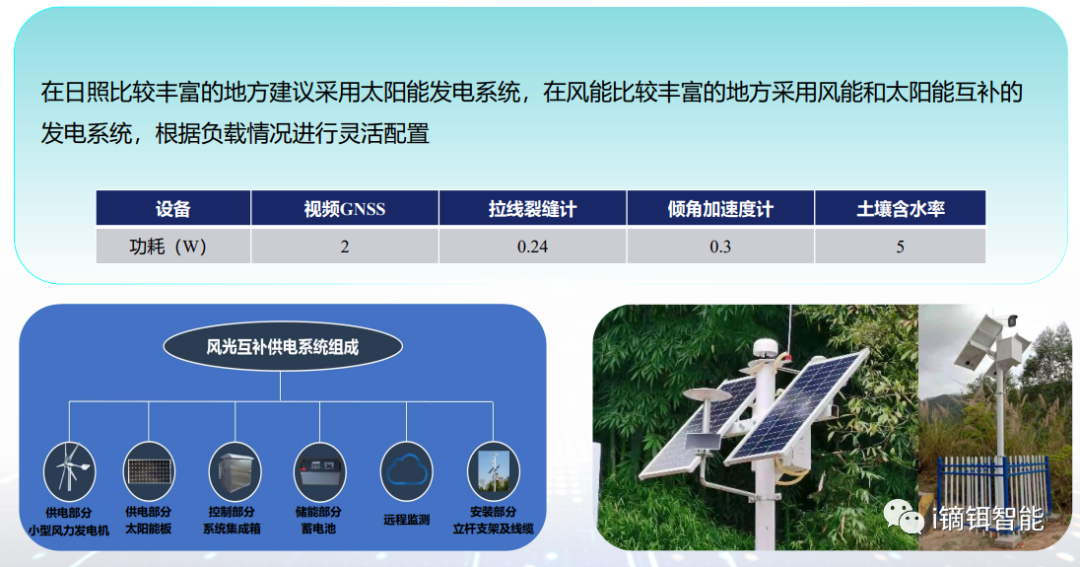
Sensor Power Supply
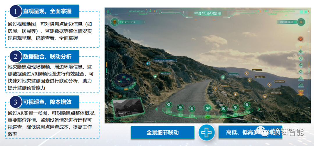
Video AR Application
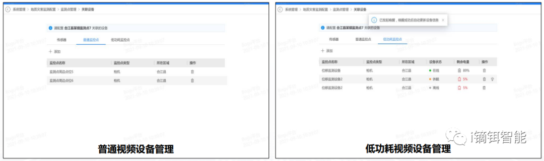
Platform Function – Monitoring Point Management
The system manages basic monitoring point information (add, delete, modify, query, details), associates devices with points, and sets warning rules (thresholds, linked captures).
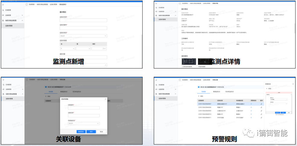
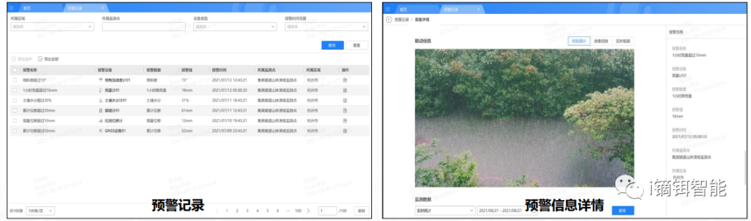
Platform Function – Monitoring Warning
The system sets four-level warning thresholds (red, orange, yellow, blue) per sensor, generates warning records with details, and allows queries by monitoring point, device type, and time range.
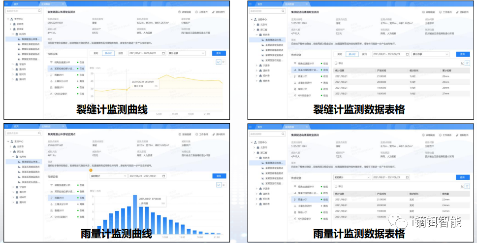
Platform Function – Monitoring Data Query
The system manages data from associated sensors, generates monitoring curves and tables, and queries data by cycle and time range.
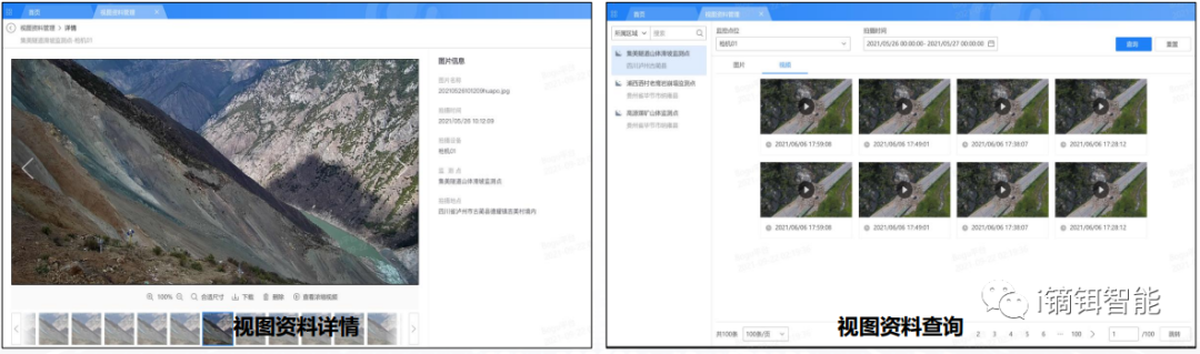
Platform Function – View Data Management
For video points with capture/recording plans, images and videos are managed with details and queries by time range, device name, and data type.
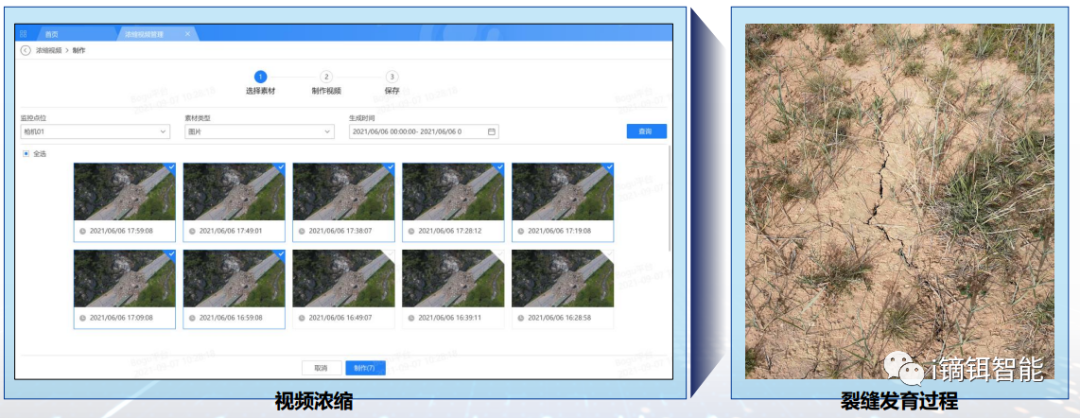
Platform Function – Hazard Development Process Monitoring
Set capture times or sensor-linked captures for overall hazard points and key areas (cracks, sinkholes, source zones). Generate time-lapse videos to monitor hazard development.
Platform Function – Sensor Device Management
The system manages sensor device info (add, delete, modify, query), device details, associated points, and supports testing, enabling, and disabling.
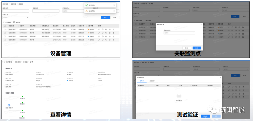
Video Device Management
The system manages video device info (add, delete, modify, query) and remotely controls devices (wake, preview, playback) via commands.
III. Application Case
Geological hazard monitoring in Ya'an, Sichuan
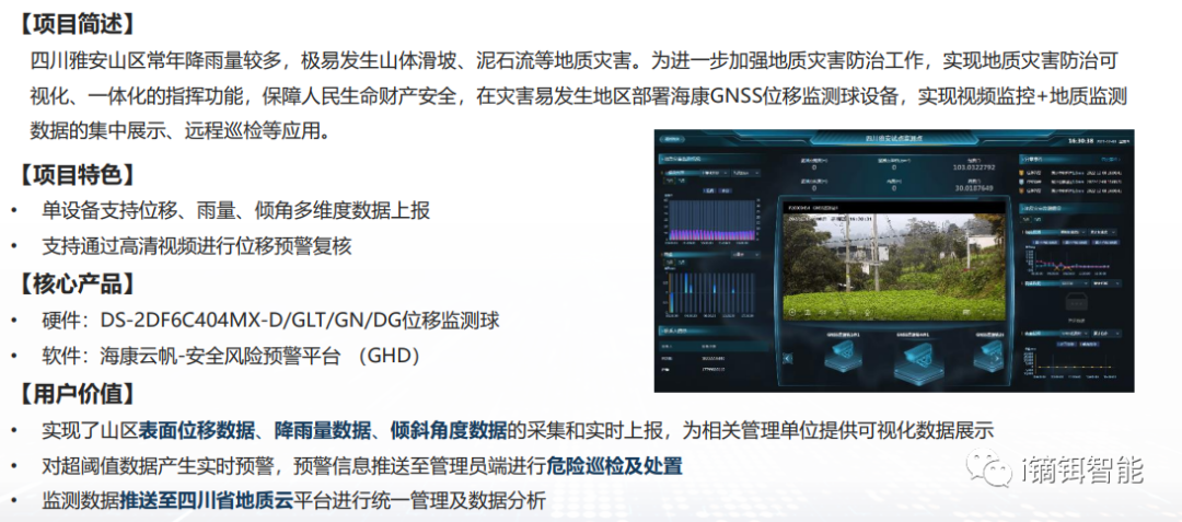
Contact: Yang, 15970160621
Note: Technical support and cooperation provided by Hikvision and Deer Intelligence.
II. Solution
Slope Monitoring Based on Sensor Technology
Video GNSS Displacement Monitoring
Surface displacement is a major trigger for geological hazards. Video GNSS equipment enables millimeter-level static accuracy for displacement monitoring, while also providing visual inspection of hazard points. Remote video inspection is supported through video linkage.
Crack Monitoring
Ground cracks are precursors to disasters, often appearing in settlement areas or around collapse zones. Wire-type crack gauges measure crack displacement for long-term monitoring.
Tilt Monitoring
Tilt deformation is a key indicator of landslides and collapses. Wireless tilt sensors provide accurate tilt measurement for monitoring settlement and deformation.
Rainfall Monitoring
Heavy rainfall is a major trigger for geological hazards. Piezoelectric rain gauges identify raindrop impact force to monitor rainfall levels from drizzle to heavy rain, with wider range, higher accuracy, and lower error.
Soil Moisture
Rainfall-induced rapid changes in soil moisture are key triggers for debris flows and landslides. Tubular integrated moisture monitoring equipment simultaneously monitors both the trigger (moisture) and result (slope tilt) for multi-parameter correlation, improving data reliability.
Sensor Power Supply
Video AR Application
Platform Function – Monitoring Point Management
The system manages basic monitoring point information (add, delete, modify, query, details), associates devices with points, and sets warning rules (thresholds, linked captures).
Platform Function – Monitoring Warning
The system sets four-level warning thresholds (red, orange, yellow, blue) per sensor, generates warning records with details, and allows queries by monitoring point, device type, and time range.
Platform Function – Monitoring Data Query
The system manages data from associated sensors, generates monitoring curves and tables, and queries data by cycle and time range.
Platform Function – View Data Management
For video points with capture/recording plans, images and videos are managed with details and queries by time range, device name, and data type.
Platform Function – Hazard Development Process Monitoring
Set capture times or sensor-linked captures for overall hazard points and key areas (cracks, sinkholes, source zones). Generate time-lapse videos to monitor hazard development.
Platform Function – Sensor Device Management
The system manages sensor device info (add, delete, modify, query), device details, associated points, and supports testing, enabling, and disabling.
Video Device Management
The system manages video device info (add, delete, modify, query) and remotely controls devices (wake, preview, playback) via commands.
III. Application Case
Geological hazard monitoring in Ya'an, Sichuan
Contact: Yang, 15970160621
Note: Technical support and cooperation provided by Hikvision and Deer Intelligence.