I. Company Team Introduction
Company Profile
Jiangxi Di Er Intelligent Technology Co., Ltd. has a team of professional R&D personnel with extensive industry experience. Dedicated to the surveying and geographic information industry, the company insists on independent innovation and continuous R&D investment. Guided by customer needs and leveraging cutting-edge technologies, we provide surveying and mapping equipment, surveying services, and GIS information solutions.
Our main products include handheld high-precision measuring devices, UAVs, and GIS information management systems. We serve customers in telecommunications, land, forestry, electric power, petrochemicals, and other industries, integrating "hardware, data, software, and services" into a comprehensive business. Targeting industry informatization and mobile internet applications, we aim to enhance the value of geographic information for customers and strive to become a competitive provider of professional mobile terminals and comprehensive solutions.
Our core team has over 5 years of experience in satellite navigation product development, industry applications, product promotion, and technical services. Main products and services include high-precision GNSS boards, high-precision BeiDou/GNSS receivers, UAVs, UAV PPK devices, high-precision UAV gyroscopes, solutions, and related software development.
Company Hardware Facilities
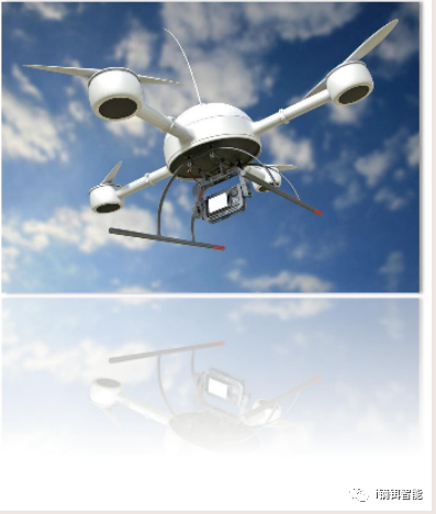
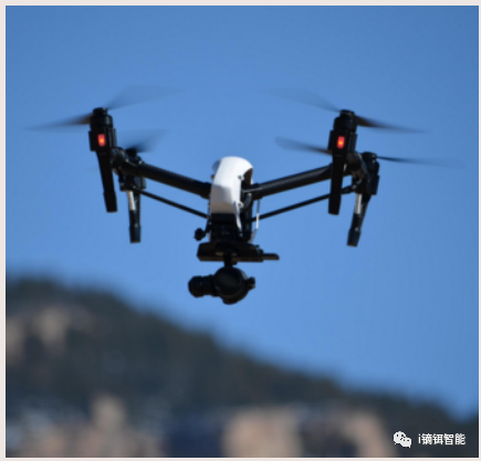
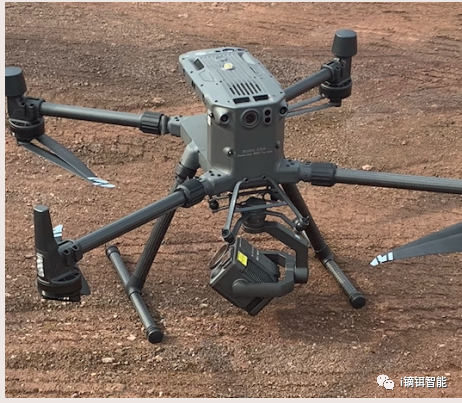
Aerial Survey Equipment: DJI M300 RTK, DJI Mavic 3 Enterprise, Oblique Photography Five-Lens, DJI Zenmuse P1, DJI Zenmuse L1
Aerial Photography Equipment: Ultra-compact multi-rotor (Mini 3 Pro), Compact multi-rotor (Mavic 3), Medium multi-rotor (Inspire 2 + X7 cinema-grade camera)
Laser Equipment: Leica equipment
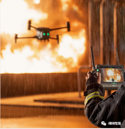
Custom Service Equipment: Infrared dual-light gimbal UAV, zoom gimbal UAV, fixed-wing UAV, gas detection UAV, loudspeaker UAV, drop UAV, banner UAV, firefighting UAV...
In-house Service Team
Field Service Team
II. Related Industry Applications
UAV Industry Overview
A UAV is an aircraft without an onboard pilot, using aerodynamics to generate lift, capable of sustained and controllable flight missions. It can carry military or civilian payloads and be disposable or reusable.
By structure, UAVs are divided into three categories: fixed-wing, helicopter, and multi-rotor. Fixed-wing and helicopter UAVs have long endurance, large payloads, and higher prices, mainly used in professional markets. Multi-rotor UAVs have four or more rotors, with advantages of simple mechanical structure and easy maintenance; disadvantages include short endurance and small payloads. Consumer-grade UAVs are mainly multi-rotor, while professional-grade UAVs are often multi-rotor or fixed-wing.
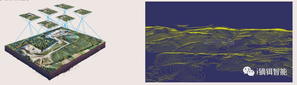
Applications in Surveying and Geographic Information
Traditional manual surveying relies mainly on satellite mapping. For the same area, the personnel and terrain mapping costs are about 10 times that of UAV aerial survey, and the construction period is about twice as long. Once purchased, UAV survey equipment has a long service life and low maintenance costs, requiring fewer personnel and higher efficiency, effectively saving field measurement time. From all aspects, the economic cost is significantly advantageous over manual surveying. Due to short operation cycles and low costs, UAV aerial survey greatly enhances the core market competitiveness of related enterprises, helping expand business and achieve good economic benefits.
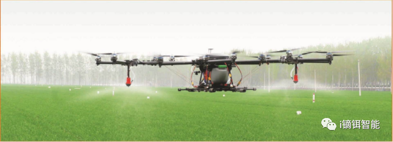
Applications in Agriculture and Forestry
The use of agricultural UAVs also improves pesticide utilization. Research published by Yuan Huizhu and others from the Institute of Plant Protection, Chinese Academy of Agricultural Sciences, titled "The Role of Plant Protection UAVs in Improving Pesticide Utilization in China," states: "Compared with traditional ground backpack high-volume spraying, low-altitude low-volume spraying from plant protection UAVs achieves pesticide utilization rates of 49.1%, 57.1%, and 52.7% for rice, wheat, and corn pest control respectively. Compared with ground backpack spraying, using agricultural UAVs can increase pesticide utilization by over 10%. For 1 billion hectares of operations, this equates to a reduction of 1,515 tons of pesticide waste." Meanwhile, compared to manual operations, agricultural UAVs save 44 liters of water per hectare.
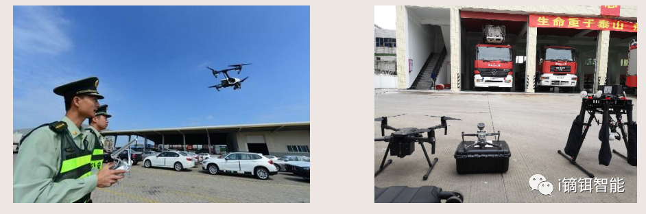
Applications in Security
In investigation and evidence collection, high-altitude reconnaissance and modeling record overall scene information and accurately reconstruct cases. In security patrols, efficient automated patrols detect risks in time, with on-site loudspeaker warnings to deter illegal acts.
In traffic enforcement, rapid response and three-dimensional perspectives efficiently secure scene evidence. In urban management inspections, quickly locate illegal buildings, reduce enforcement costs, and achieve digital city management.
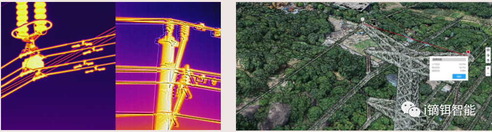
Applications in Inspection
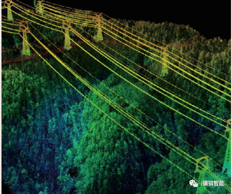
Perform rapid 3D real-scene modeling of power grid corridors, obtain visual precise data, and effectively reduce operation and maintenance costs. Increase the speed and frequency of power grid inspections to effectively prevent external damage. Refined and automated UAV inspections efficiently provide standardized data and promptly detect fault risks. Perform instant temperature analysis of grid equipment to quickly identify anomalies. Through multi-angle, close-range inspections, quickly locate fault points and eliminate faults in time.
III. Main Business Overview
Main Business
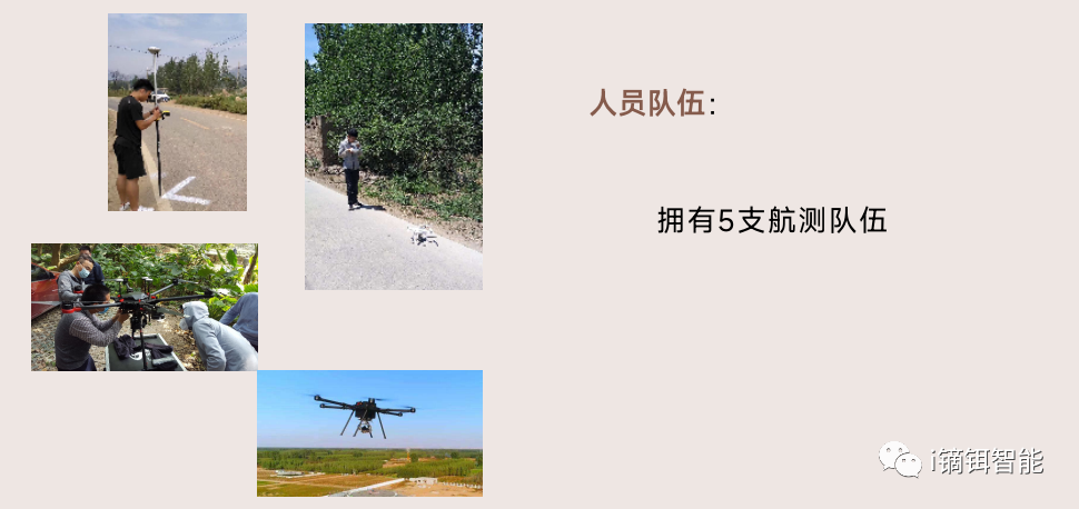
UAV Aerial Flight: Large-scale aerial photography original data collection, high-resolution large-area oblique photography original data collection, control point layout.
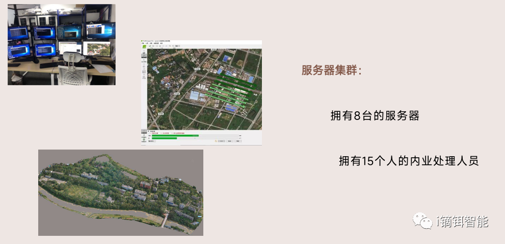
In-house Data Processing: Cluster server data production, through effective data processing and data compilation, the survey data and materials obtained in the field are turned into results.
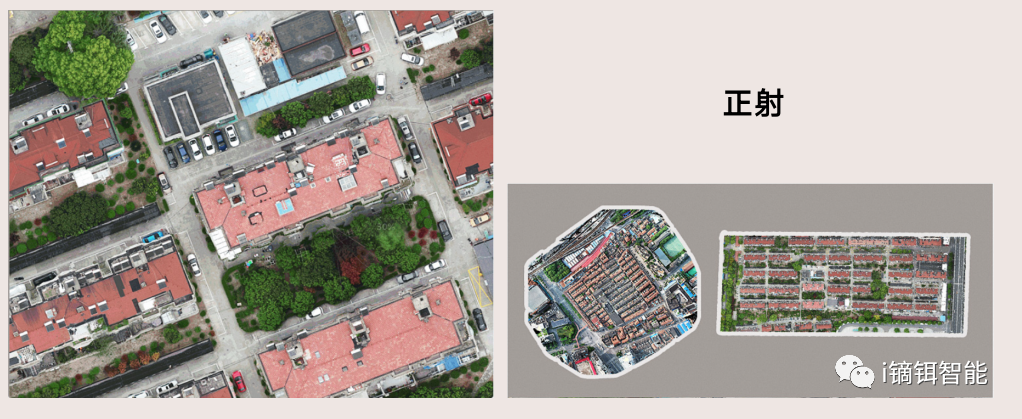
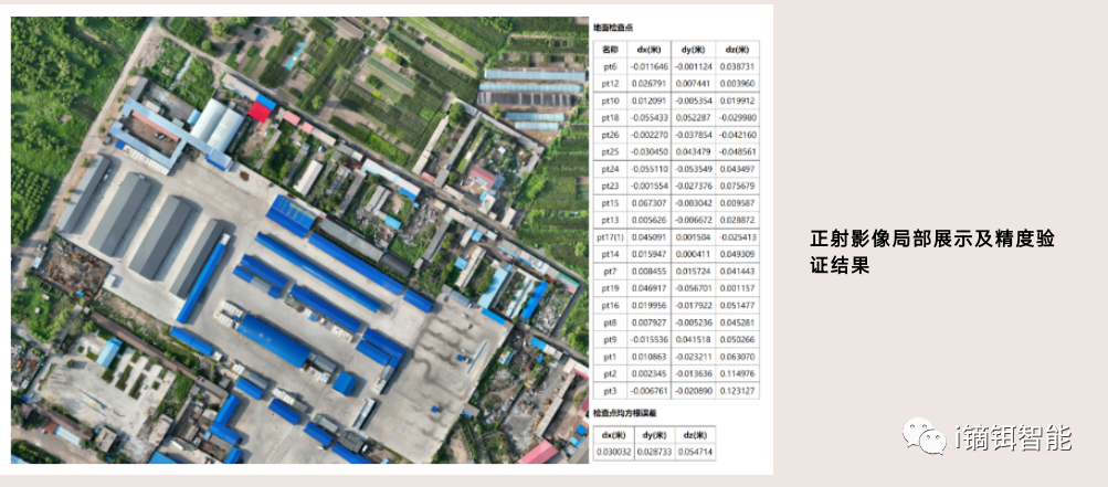
4D Product Production: Aerial triangulation, 4D digital product production, large-scale digital orthophoto maps (1/500, 1/1000, 1/2000), digital line graphics, digital elevation models, etc.
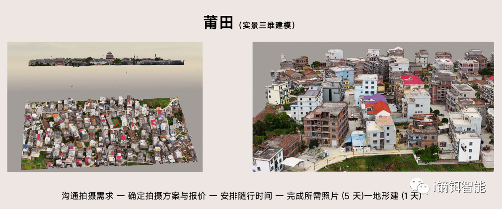
Oblique 3D Modeling: High-resolution, large-area oblique photography 3D modeling.
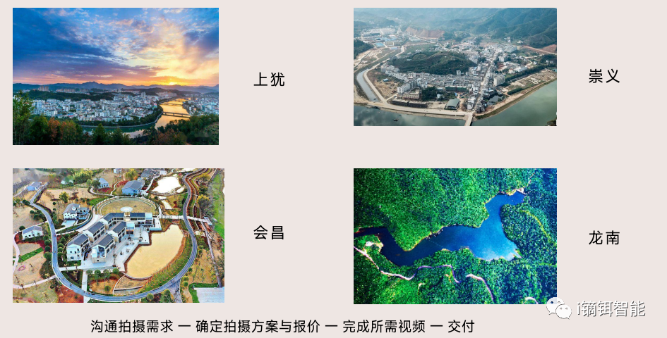
Aerial Photography Services
Architecture photography, 720° panorama, construction site shooting, mining area shooting, scenic area shooting, Douyin shooting, project reporting, event shooting, fleet shooting, road shooting, river channel shooting, property plots, night aerial photography, promotional videos, flash mob shooting, team building shooting.
Aerial Survey Services
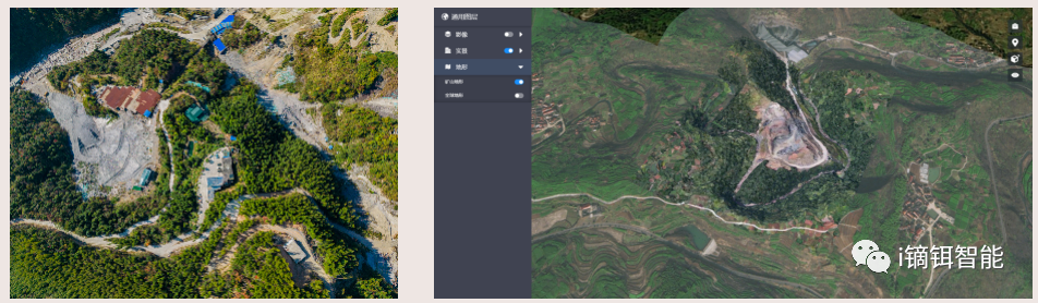
Mine surveying (mine terrain, contour maps, mine surface area [greening]), road surveying, construction site surveying, highway surveying, earthwork calculation (fill volume, mine cavity, cut volume), area calculation (collapse zones, cross-section analysis), soil erosion, height measurement, facade measurement (spatial distance analysis), BIM, big data.
Deliverables: DSM, DLG, high-definition orthophotos, 3D model maps, 3D topographic maps...
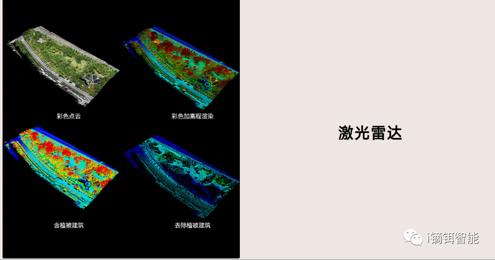
Laser Mapping
Millimeter-level accuracy, construction inspection, BIM, mold reading, building surveying, road surveying, bridge surveying, power inspection, no-fly zone surveying, factory digitization.
Custom Services
3D model rendering, dual-light photography, long-endurance photography, ultra-long-range zoom photography, photovoltaic inspection, archaeology, river channel inspection, and other customized services.
IV. Work Cases
Xinrong Tungsten Mine Topographic Survey
Partial Work Cases
Contact: Yang 15970160621
Note: Technical support for this product is provided by Di Er Intelligent.
Company Profile
Jiangxi Di Er Intelligent Technology Co., Ltd. has a team of professional R&D personnel with extensive industry experience. Dedicated to the surveying and geographic information industry, the company insists on independent innovation and continuous R&D investment. Guided by customer needs and leveraging cutting-edge technologies, we provide surveying and mapping equipment, surveying services, and GIS information solutions.
Our main products include handheld high-precision measuring devices, UAVs, and GIS information management systems. We serve customers in telecommunications, land, forestry, electric power, petrochemicals, and other industries, integrating "hardware, data, software, and services" into a comprehensive business. Targeting industry informatization and mobile internet applications, we aim to enhance the value of geographic information for customers and strive to become a competitive provider of professional mobile terminals and comprehensive solutions.
Our core team has over 5 years of experience in satellite navigation product development, industry applications, product promotion, and technical services. Main products and services include high-precision GNSS boards, high-precision BeiDou/GNSS receivers, UAVs, UAV PPK devices, high-precision UAV gyroscopes, solutions, and related software development.
Company Hardware Facilities
Aerial Survey Equipment: DJI M300 RTK, DJI Mavic 3 Enterprise, Oblique Photography Five-Lens, DJI Zenmuse P1, DJI Zenmuse L1
Aerial Photography Equipment: Ultra-compact multi-rotor (Mini 3 Pro), Compact multi-rotor (Mavic 3), Medium multi-rotor (Inspire 2 + X7 cinema-grade camera)
Laser Equipment: Leica equipment
Custom Service Equipment: Infrared dual-light gimbal UAV, zoom gimbal UAV, fixed-wing UAV, gas detection UAV, loudspeaker UAV, drop UAV, banner UAV, firefighting UAV...
In-house Service Team
Field Service Team
II. Related Industry Applications
UAV Industry Overview
A UAV is an aircraft without an onboard pilot, using aerodynamics to generate lift, capable of sustained and controllable flight missions. It can carry military or civilian payloads and be disposable or reusable.
By structure, UAVs are divided into three categories: fixed-wing, helicopter, and multi-rotor. Fixed-wing and helicopter UAVs have long endurance, large payloads, and higher prices, mainly used in professional markets. Multi-rotor UAVs have four or more rotors, with advantages of simple mechanical structure and easy maintenance; disadvantages include short endurance and small payloads. Consumer-grade UAVs are mainly multi-rotor, while professional-grade UAVs are often multi-rotor or fixed-wing.
Applications in Surveying and Geographic Information
Traditional manual surveying relies mainly on satellite mapping. For the same area, the personnel and terrain mapping costs are about 10 times that of UAV aerial survey, and the construction period is about twice as long. Once purchased, UAV survey equipment has a long service life and low maintenance costs, requiring fewer personnel and higher efficiency, effectively saving field measurement time. From all aspects, the economic cost is significantly advantageous over manual surveying. Due to short operation cycles and low costs, UAV aerial survey greatly enhances the core market competitiveness of related enterprises, helping expand business and achieve good economic benefits.
Applications in Agriculture and Forestry
The use of agricultural UAVs also improves pesticide utilization. Research published by Yuan Huizhu and others from the Institute of Plant Protection, Chinese Academy of Agricultural Sciences, titled "The Role of Plant Protection UAVs in Improving Pesticide Utilization in China," states: "Compared with traditional ground backpack high-volume spraying, low-altitude low-volume spraying from plant protection UAVs achieves pesticide utilization rates of 49.1%, 57.1%, and 52.7% for rice, wheat, and corn pest control respectively. Compared with ground backpack spraying, using agricultural UAVs can increase pesticide utilization by over 10%. For 1 billion hectares of operations, this equates to a reduction of 1,515 tons of pesticide waste." Meanwhile, compared to manual operations, agricultural UAVs save 44 liters of water per hectare.
Applications in Security
In investigation and evidence collection, high-altitude reconnaissance and modeling record overall scene information and accurately reconstruct cases. In security patrols, efficient automated patrols detect risks in time, with on-site loudspeaker warnings to deter illegal acts.
In traffic enforcement, rapid response and three-dimensional perspectives efficiently secure scene evidence. In urban management inspections, quickly locate illegal buildings, reduce enforcement costs, and achieve digital city management.
Applications in Inspection
Perform rapid 3D real-scene modeling of power grid corridors, obtain visual precise data, and effectively reduce operation and maintenance costs. Increase the speed and frequency of power grid inspections to effectively prevent external damage. Refined and automated UAV inspections efficiently provide standardized data and promptly detect fault risks. Perform instant temperature analysis of grid equipment to quickly identify anomalies. Through multi-angle, close-range inspections, quickly locate fault points and eliminate faults in time.
III. Main Business Overview
Main Business
UAV Aerial Flight: Large-scale aerial photography original data collection, high-resolution large-area oblique photography original data collection, control point layout.
In-house Data Processing: Cluster server data production, through effective data processing and data compilation, the survey data and materials obtained in the field are turned into results.
4D Product Production: Aerial triangulation, 4D digital product production, large-scale digital orthophoto maps (1/500, 1/1000, 1/2000), digital line graphics, digital elevation models, etc.
Oblique 3D Modeling: High-resolution, large-area oblique photography 3D modeling.
Aerial Photography Services
Architecture photography, 720° panorama, construction site shooting, mining area shooting, scenic area shooting, Douyin shooting, project reporting, event shooting, fleet shooting, road shooting, river channel shooting, property plots, night aerial photography, promotional videos, flash mob shooting, team building shooting.
Aerial Survey Services
Mine surveying (mine terrain, contour maps, mine surface area [greening]), road surveying, construction site surveying, highway surveying, earthwork calculation (fill volume, mine cavity, cut volume), area calculation (collapse zones, cross-section analysis), soil erosion, height measurement, facade measurement (spatial distance analysis), BIM, big data.
Deliverables: DSM, DLG, high-definition orthophotos, 3D model maps, 3D topographic maps...
Laser Mapping
Millimeter-level accuracy, construction inspection, BIM, mold reading, building surveying, road surveying, bridge surveying, power inspection, no-fly zone surveying, factory digitization.
Custom Services
3D model rendering, dual-light photography, long-endurance photography, ultra-long-range zoom photography, photovoltaic inspection, archaeology, river channel inspection, and other customized services.
IV. Work Cases
Xinrong Tungsten Mine Topographic Survey
Partial Work Cases
Contact: Yang 15970160621
Note: Technical support for this product is provided by Di Er Intelligent.