1. Geological Modeling and Resource Estimation Solution
Geological modeling and resource estimation
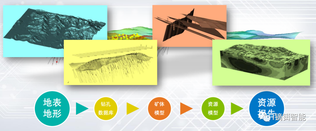
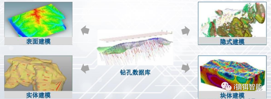
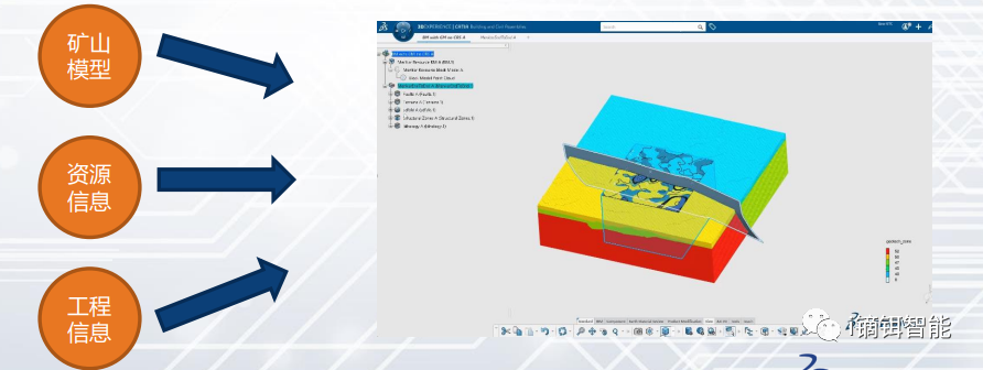
Based on exploration data from different mine stages (including drillhole, trench, and blast hole data), create orebody models, rock mass models, and fault models. Build grade models using reserve estimation tools.
The geological model can be updated as new production exploration data becomes available. It supports reserve quantity statistics, grade classification, and serves as part of the mine production planning platform.
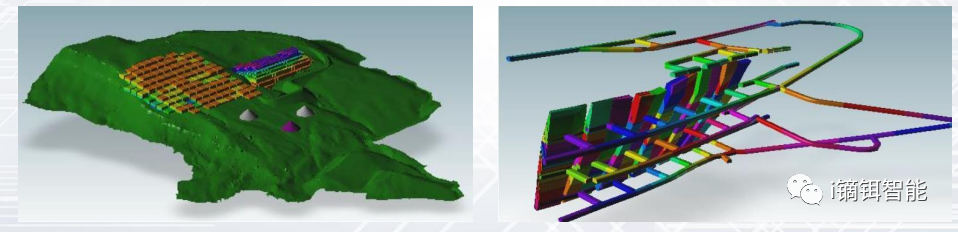
2. Underground Mine Design and Stope Optimization Solution
Current mining faces multiple challenges, requiring more efficient, economical, and reliable mine planning.
Underground mine design and optimization
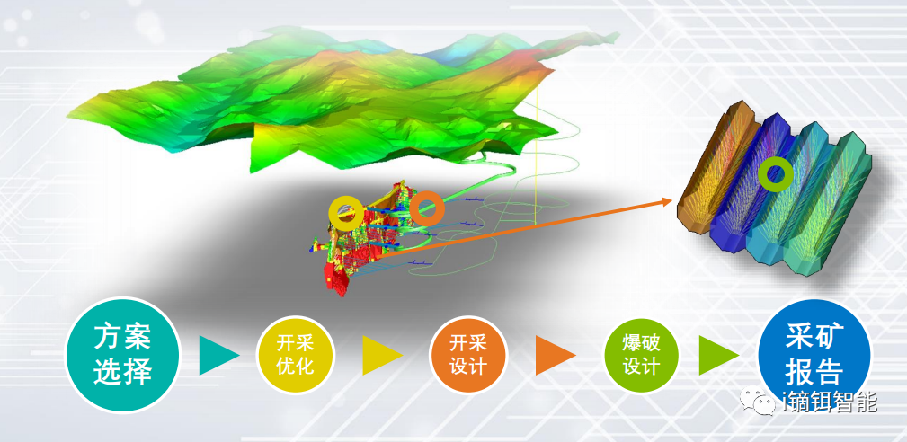
Generates optimized stope shapes for most underground mining methods.
Produces stope inventory lists from block models representing mineralized zones.
Delivers stope shapes maximizing recovery beyond cutoff grades or boundaries.
Supports practical mining parameters such as min/max stoping width, expected dilution, min/max stope boundary angles, and other factors.
3. Underground/Open-Pit Production Scheduling Solution
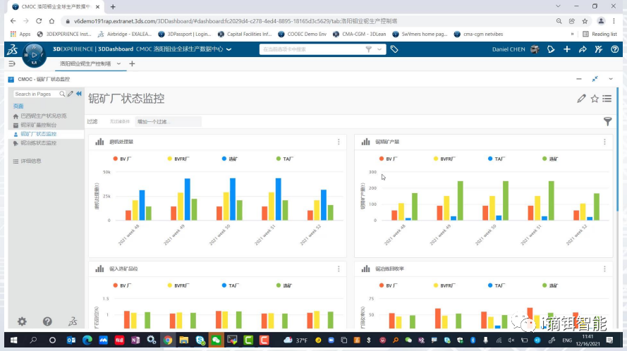
Mine production scheduling
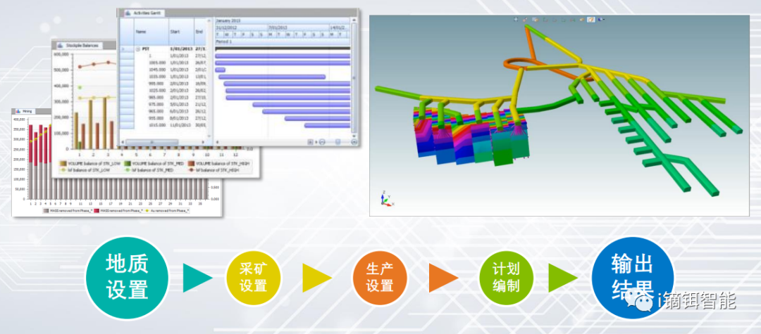
Based on geological resources and current mining status, prepare long-term, medium-term, and short-term production plans.
Intelligent scheduling in a virtual mine environment improves efficiency and plan feasibility. Supports blending optimization. Planning outputs include scope, model, and data for comparison with actual progress.
Advantages and Limitations of Traditional 3D Mining Software
Advantages:
Powerful professional tools;
Comprehensive mineral resource information;
Meets academic research requirements;
Strong secondary development capability.
Limitations:
Difficult to integrate with information systems;
Not suitable for light users, management, or mobile office;
Data transferred locally hand-to-hand, causing disconnection;
Information scattered, requiring professional software operation, low efficiency.
4. Integrated Geo-Survey-Mining Solution - Key Functions
Platform basic functions
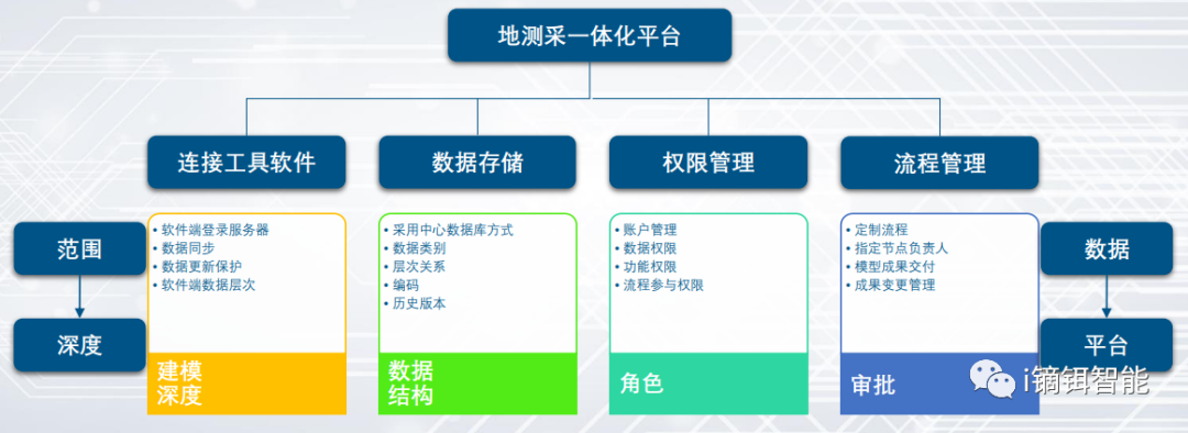
Software connection function
Launch tool software from a unified interface;
Auto-login to platform for easy data access/submission.
Data storage function
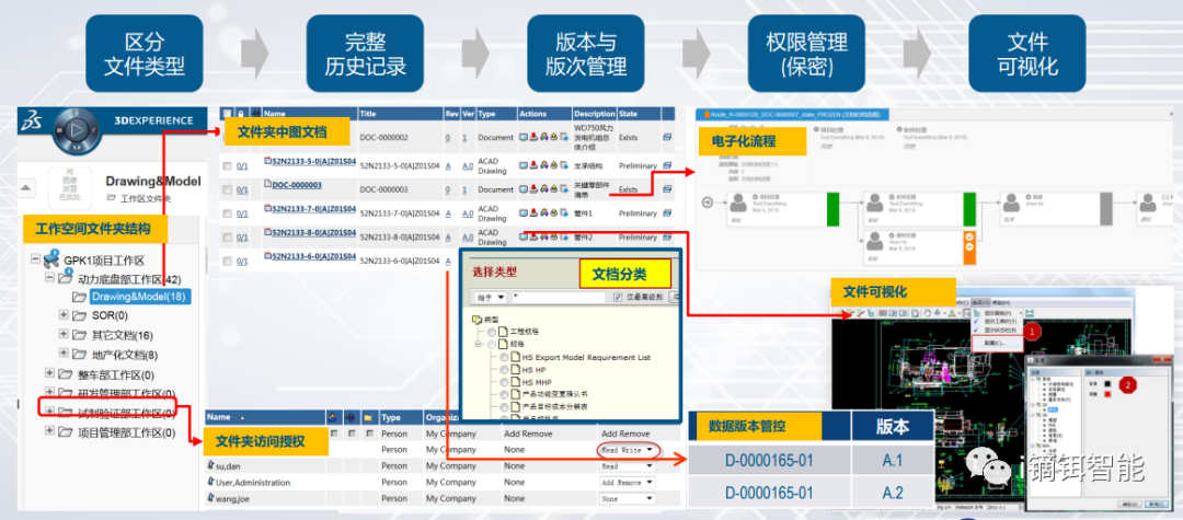
Permission management function
User login with account, assigned different roles and permissions;
Control visibility of various platform elements (data, processes, functions);
Provide user permission editing and management tools.
Process management function
Quickly establish business processes by creating personnel lists and flowcharts;
Assign process owners, managers, participants, and approvers;
Convenient backend tools for rapid process setup.
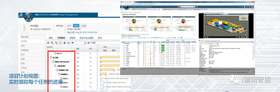
Task progress management function
Task managers can create and assign tasks, track progress, and generate statistics;
Define task workflows and related personnel;
Directly submit model data within tasks.
Data analysis function
Geo-survey-mining data integration function
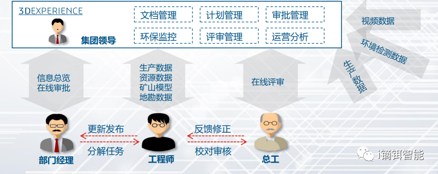
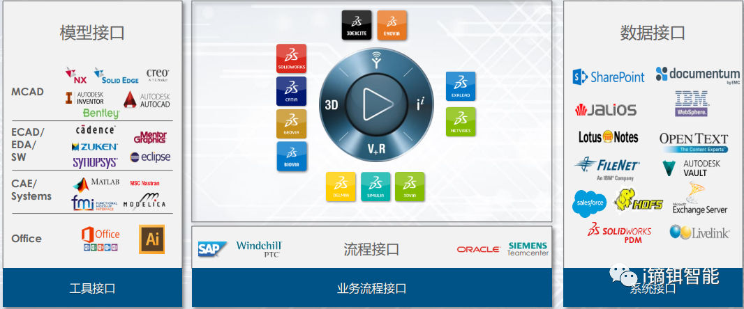
Centralize structured and unstructured geoscience information on the 3DEXPERIENCE platform;
Unify existing geological background and engineering conditions (drillholes, geological models, aquifers) as single source of truth;
Enable synchronized understanding across roles with permissions, improving multidisciplinary integration.
System integration function
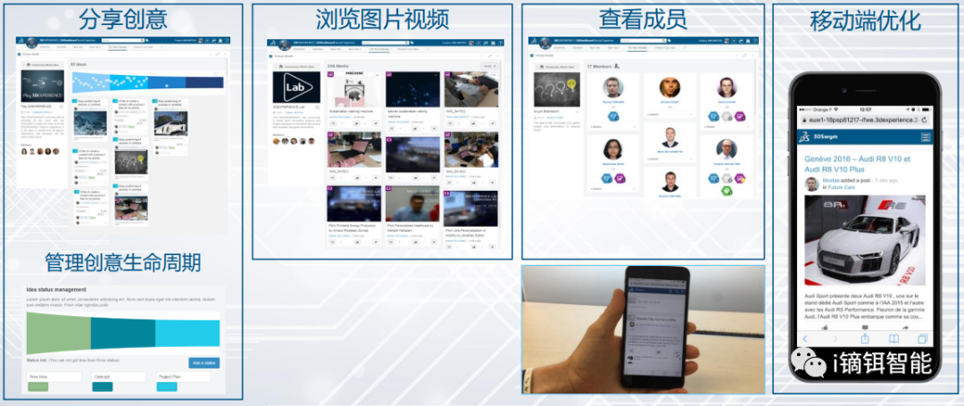
Community and instant messaging function
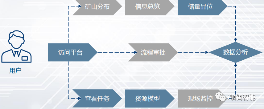
5. Application Scenarios
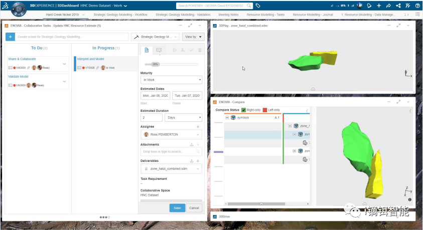
Exploration data update + model change collaboration scenario
Task assignment + geological model update + result submission scenario
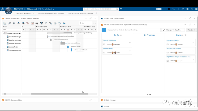
Department task management + work result verification + data analysis scenario
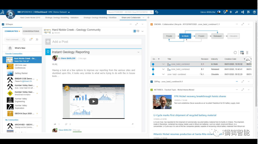
Business intelligence + team interaction + task collaboration scenario
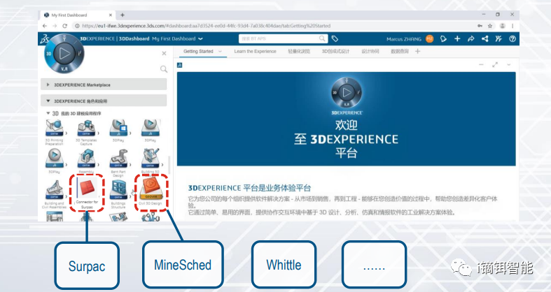
Integrated Geo-Survey-Mining Solution
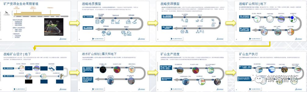
Based on Dassault Systèmes' 3DEXPERIENCE platform, the solution integrates GEOVIA Surpac, MineSched, and other professional tools into a unified data environment. It connects traditional geology, mining, surveying, and production planning workflows to form a closed-loop geo-survey-mining process, improving the working ecosystem and efficiency.
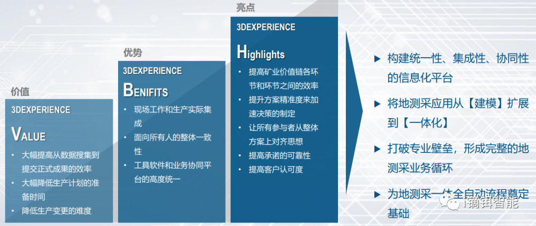
6. Value Summary
Value summary of integrated geo-survey-mining solution
Contact: Yang 15970160621
Note: Technical support and cooperation provided by Dassault Systèmes and DyEr Intelligence.
Geological modeling and resource estimation
Based on exploration data from different mine stages (including drillhole, trench, and blast hole data), create orebody models, rock mass models, and fault models. Build grade models using reserve estimation tools.
The geological model can be updated as new production exploration data becomes available. It supports reserve quantity statistics, grade classification, and serves as part of the mine production planning platform.
2. Underground Mine Design and Stope Optimization Solution
Current mining faces multiple challenges, requiring more efficient, economical, and reliable mine planning.
Underground mine design and optimization
Generates optimized stope shapes for most underground mining methods.
Produces stope inventory lists from block models representing mineralized zones.
Delivers stope shapes maximizing recovery beyond cutoff grades or boundaries.
Supports practical mining parameters such as min/max stoping width, expected dilution, min/max stope boundary angles, and other factors.
3. Underground/Open-Pit Production Scheduling Solution
Mine production scheduling
Based on geological resources and current mining status, prepare long-term, medium-term, and short-term production plans.
Intelligent scheduling in a virtual mine environment improves efficiency and plan feasibility. Supports blending optimization. Planning outputs include scope, model, and data for comparison with actual progress.
Advantages and Limitations of Traditional 3D Mining Software
Advantages:
Powerful professional tools;
Comprehensive mineral resource information;
Meets academic research requirements;
Strong secondary development capability.
Limitations:
Difficult to integrate with information systems;
Not suitable for light users, management, or mobile office;
Data transferred locally hand-to-hand, causing disconnection;
Information scattered, requiring professional software operation, low efficiency.
4. Integrated Geo-Survey-Mining Solution - Key Functions
Platform basic functions
Software connection function
Launch tool software from a unified interface;
Auto-login to platform for easy data access/submission.
Data storage function
Permission management function
User login with account, assigned different roles and permissions;
Control visibility of various platform elements (data, processes, functions);
Provide user permission editing and management tools.
Process management function
Quickly establish business processes by creating personnel lists and flowcharts;
Assign process owners, managers, participants, and approvers;
Convenient backend tools for rapid process setup.
Task progress management function
Task managers can create and assign tasks, track progress, and generate statistics;
Define task workflows and related personnel;
Directly submit model data within tasks.
Data analysis function
Geo-survey-mining data integration function
Centralize structured and unstructured geoscience information on the 3DEXPERIENCE platform;
Unify existing geological background and engineering conditions (drillholes, geological models, aquifers) as single source of truth;
Enable synchronized understanding across roles with permissions, improving multidisciplinary integration.
System integration function
Community and instant messaging function
5. Application Scenarios
Exploration data update + model change collaboration scenario
Task assignment + geological model update + result submission scenario
Department task management + work result verification + data analysis scenario
Business intelligence + team interaction + task collaboration scenario
Integrated Geo-Survey-Mining Solution
Based on Dassault Systèmes' 3DEXPERIENCE platform, the solution integrates GEOVIA Surpac, MineSched, and other professional tools into a unified data environment. It connects traditional geology, mining, surveying, and production planning workflows to form a closed-loop geo-survey-mining process, improving the working ecosystem and efficiency.
6. Value Summary
Value summary of integrated geo-survey-mining solution
Contact: Yang 15970160621
Note: Technical support and cooperation provided by Dassault Systèmes and DyEr Intelligence.