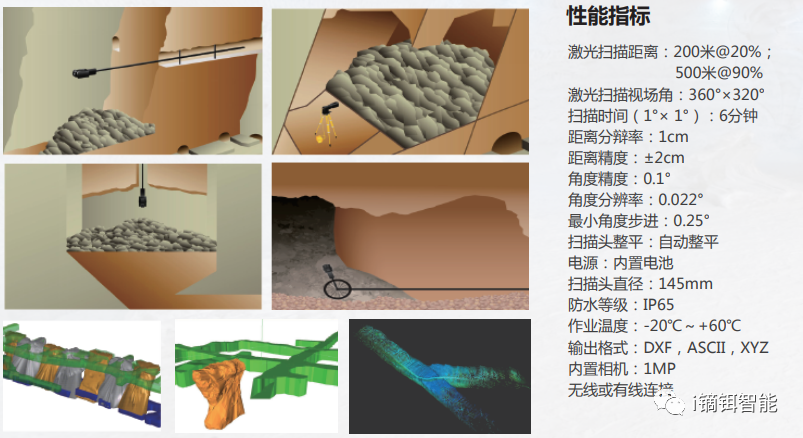
1. Explosion-Proof Cavity 3D Laser Scanner
CMS V500
Suitable for measuring underground cavities, roadways, and ore passes. Integrated, lightweight, portable, easy to operate, short scanning time. Exports xyz, dxf, asc formats. Unique for dangerous areas inaccessible to personnel.
Provides real 3D models from point cloud data for digital mining.
Performance Indicators
Advantages
Explosion-proof; fast, accurate, safe point cloud acquisition; real-time data visualization; compatible with mining software (Surpac, VULCAN) and CAD; built-in camera for inspection; non-contact measurement; simple control software; built-in attitude sensor; 360°×320° scan range; remote operation; carbon fiber body.
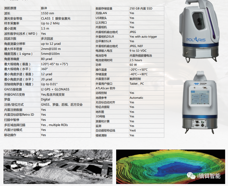
2. Long-Range 3D Laser Scanner
Product Parameters
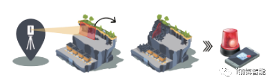
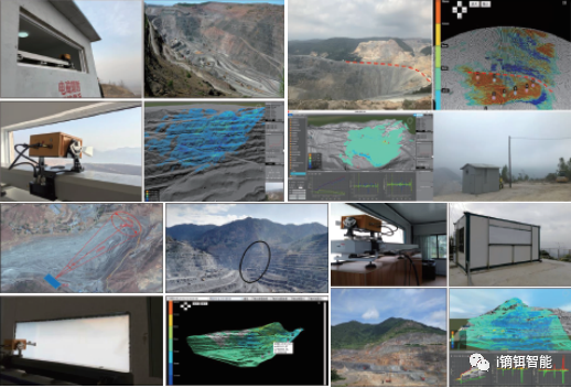
Mine Automatic Monitoring System
Using Polaris 3D laser scanner for real-time monitoring of dangerous areas. The automatic system controls scanning at specified times, compares point clouds with previous data, triggers alerts when displacement exceeds threshold.
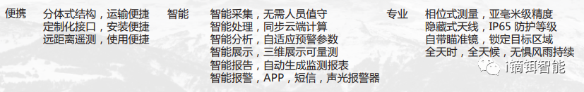
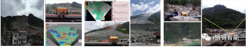
3. Portable Slope Radar
Millimeter-level deformation measurement for open-pit slopes, dam slopes, landslides, large structures. Continuous real-time monitoring, early warning for collapse disasters. Used for safety assurance, health assessment, emergency rescue.
Product Features
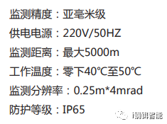
Technical Parameters
Applications
Open-pit mines, emergency rescue, geological survey, water conservancy, hydraulic power, roads, bridges, railways, tunnels.
4. Borehole Underground Cavity 3D Laser Scanner
Product Features
GLS system consists of probe, control box, Kevlar cable. Electric winch, integrated high-precision electronic compass, tilt sensor, laser rangefinder, HD infrared camera, auto-clutch protection, fiberglass encoder.
5cm diameter design allows insertion into confined spaces via borehole – a 3D 'endoscope'. Requires 1 technician + 2 assistants. Fine measurement
CMS V500
Suitable for measuring underground cavities, roadways, and ore passes. Integrated, lightweight, portable, easy to operate, short scanning time. Exports xyz, dxf, asc formats. Unique for dangerous areas inaccessible to personnel.
Provides real 3D models from point cloud data for digital mining.
Performance Indicators
Advantages
Explosion-proof; fast, accurate, safe point cloud acquisition; real-time data visualization; compatible with mining software (Surpac, VULCAN) and CAD; built-in camera for inspection; non-contact measurement; simple control software; built-in attitude sensor; 360°×320° scan range; remote operation; carbon fiber body.
2. Long-Range 3D Laser Scanner
Product Parameters
Mine Automatic Monitoring System
Using Polaris 3D laser scanner for real-time monitoring of dangerous areas. The automatic system controls scanning at specified times, compares point clouds with previous data, triggers alerts when displacement exceeds threshold.
3. Portable Slope Radar
Millimeter-level deformation measurement for open-pit slopes, dam slopes, landslides, large structures. Continuous real-time monitoring, early warning for collapse disasters. Used for safety assurance, health assessment, emergency rescue.
Product Features
Technical Parameters
Applications
Open-pit mines, emergency rescue, geological survey, water conservancy, hydraulic power, roads, bridges, railways, tunnels.
4. Borehole Underground Cavity 3D Laser Scanner
Product Features
GLS system consists of probe, control box, Kevlar cable. Electric winch, integrated high-precision electronic compass, tilt sensor, laser rangefinder, HD infrared camera, auto-clutch protection, fiberglass encoder.
5cm diameter design allows insertion into confined spaces via borehole – a 3D 'endoscope'. Requires 1 technician + 2 assistants. Fine measurement